Real vs. Anime: Visualizing the Iconic Real-World Locations of 'Your Name'
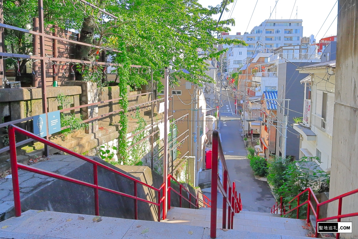
A quiet residential staircase in Tokyo's Yotsuya neighborhood draws dozens of travelers every hour, cameras clutched in hand, waiting for the sun to hit the red handrails at an angle of roughly forty-five degrees. A decade after Makoto Shinkai released Your Name (Kimi no Na wa) in 2016, the international obsession with visiting its physical backdrops has rewritten Japan’s travel economy. What began as grassroots fan sleuthing has evolved into state-coordinated civic planning. As detailed in a recent Unseen Japan Report on the transition of anime pilgrimage from subculture to municipal infrastructure, these real-world anime settings now anchor multimillion-dollar regional transit networks, regional revitalization campaigns, and permanent municipal preservation budgets.
The practice of seichi junrei, literally "sacred site pilgrimage", is no longer an insular hobby. For Shinkai’s blockbuster, the pursuit bridges bustling Shinjuku intersections with misty valleys in Gifu and caldera vistas in Nagano. The animation studio, CoMix Wave Films, recreated Japan’s urban and rural geography with photorealistic precision. Understanding why these sites hold enduring cultural power requires looking past the screen to examine the physical environments that inspired them.
📌 Key Takeaways:
- The Tokyo Nexus: Suga Shrine stairs in Yotsuya and the NTT Docomo Yoyogi Building remain central urban anchors, sustaining consistent foot traffic year-round.
- The Rural Composite: The fictional town of Itomori does not exist on a map; it is a meticulous composite blending Nagano's Lake Suwa with the heritage architecture of Hida-Furukawa in Gifu Prefecture.
- Civic Evolution: Gifu Prefecture tourism and municipal boards have institutionalized anime tourism infrastructure, turning temporary fan curiosity into lasting local tax revenue.
Suga Shrine Stairs and Tokyo's Urban Topography
The climactic visual of Your Name, two estranged protagonists passing each other on a steep, narrow flight of stairs, belongs to Suga Shrine in Shinjuku’s Yotsuya district. In the film, the sequence captures an ache of missed connections. In reality, the stairs are wedged into a sleepy, residential labyrinth five minutes from Yotsuya-Sanchome Station. The lacquer-red lacquered metal handrails, the concrete retaining wall, and the gentle slope toward the residential intersection below match the animated frames down to individual brick divisions.
Urban exploration extends beyond Suga Shrine. A standard Yotsuya Tokyo anime tour leads fans through several precise vantage points: the pedestrian footbridge outside Shinanomachi Station, the intersection under the Shinjuku labor office, and the dramatic silhouette of the NTT Docomo Yoyogi Building puncturing the early morning fog. Shinkai’s team photographed these urban structures at hyper-specific focal lengths, using real-world optical distortions to make ordinary metropolitan infrastructure feel intensely cinematic. Travelers standing at the Shinanomachi overpass routinely position their smartphones to align real road signs with film stills, proving that the artistic power lies not in fantasy landscapes, but in making asphalt and concrete feel sacred.
Decoding Itomori: Lake Suwa and the Nagano Caldera Myth
Screenwriters invented the doomed mountain hamlet of Itomori, but the topography comes directly from Nagano Prefecture. Lake Suwa, a massive tectonic lake ringed by mountains, serves as the unmistakable visual blueprint for the body of water that dominates the town's geography. Looking down from Tateishi Park on the lake’s northeastern ridge, visitors can see the identical circular rim and sun-dappled surface rendered during the film's twilight sequences.
The geographic reality contains distinct differences from the narrative. In the film, Itomori is framed as an isolated, rural settlement rooted in pre-modern Shinto rituals. Lake Suwa, by contrast, is flanked by modern mid-sized cities, Suwa and Okaya, complete with precision manufacturing hubs and hot spring resort hotels. Yet Shinkai stripped away industrial sprawl while retaining the essential geological bowl. Tateishi Park now features viewing decks tailored specifically for visitors looking to catch the golden hour glow, illustrating how regional authorities recognized the economic value of preserving sightlines originally made famous on celluloid.
Hida-Furukawa: How a Sleepy Gifu Town Engineered Anime Tourism
While Lake Suwa provided the body of water, Gifu Prefecture supplied the cultural and structural bone of the rural setting. Hida-Furukawa Station, a small stop on the JR Takayama Main Line, serves as the arrival point when Taki journeys north to find Mitsuha. The film reproduces the station’s pedestrian overpass, the single-track platform layout, and the taxi stand with astonishing fidelity.
When the movie shattered box office records, the Hida City government made a calculated choice: instead of curbing visitors, they mobilized. The municipal library, where Taki pores over historical registers of the comet disaster, created an official, quiet photography zone for anime tourists, complete with signs explaining library etiquette in English, Japanese, and Mandarin. Local shops stocking kuchikamizake bottles (recreated using local sake breweries) and traditional braided silk cords (kumihimo) saw production backlogs stretch into months. What could have been an intrusive wave of disruptive tourism was swiftly assimilated into daily community operations.
Mapping the Geography: Anime Frames vs. Physical Reality
Visiting these anime sacred sites requires navigating distinct regional transit systems across central Japan. The structural reality behind the production reveals an intentional mosaic of diverse prefectures:
| Location & Target Spot | Film Role | Physical Function & Access | Visitor Management Features |
|---|---|---|---|
| Suga Shrine Stairs(Yotsuya, Tokyo) | Final reunion scene; promotional theatrical poster background. | Active residential street staircase; 5-minute walk from Yotsuya-Sanchome Station. | Multilingual quiet-zone signs; strict prohibitions on tripod gear. |
| Tateishi Park / Lake Suwa(Suwa, Nagano) | Visual base for Lake Itomori during the sunset kataware-doki scenes. | Public municipal hilltop park; accessible by local bus or 15-minute taxi from Kami-Suwa Station. | Reinforced viewing platforms, dusk lighting, seasonal shuttle services. |
| Hida-Furukawa Station(Hida, Gifu) | Transit hub where Taki investigates the northern countryside. | Functioning JR Central train station; 3-hour express train from Nagoya. | Train-spotting schedule guides, bilingual photo platforms, mascot installations. |
| Hida City Library(Hida, Gifu) | Archive where Taki searches records of the fragmented meteor strike. | Public municipal library; 7-minute walk from Hida-Furukawa Station. | Designated visitor check-in desk, silent camera permits, dedicated display shelf. |
From Subculture Footpaths to Municipal Infrastructure
In the early 2010s, anime pilgrimages were sporadic, unorganized movements. When fans converged on rural towns, residents often reacted with confusion or distress. The sheer scale of the Your Name pilgrimage forced a profound shift. Municipal authorities in Gifu recognized that inbound tourism could cushion against severe population decline and shrinking rural economies.
Hida’s municipal office worked directly with regional transit authorities. JR Central introduced specialized routing and coordinated marketing campaigns, while local craft workshops expanded traditional kumihimo braiding classes to accommodate international booking portals. Regional planning documents show that Gifu Prefecture tourism captured billions of yen in direct consumer spending in the years following the film's theatrical release. The municipality proved that anime tourism, when supported by solid infrastructure rather than dismissed as a passing craze, can establish permanent economic lifelines for regions facing demographic contraction.
Resident Friction and the Etiquette of Sacred Sites
Mass foot traffic brings inevitable friction to historic neighborhoods. The residential blocks flanking Suga Shrine in Tokyo house retirees and families who face camera-wielding visitors at all hours of the day. In response, local neighborhood associations (chonaikai) installed discreet warnings reminding visitors that the steps are public thoroughfares, not soundstages. Blocking foot traffic, lingering on private properties, and flying drones carry swift intervention from municipal police patrols.
In Hida-Furukawa, preservation strategies focus on visitor dispersion. Rather than funneling all tourists into the train station overpass, local tourism maps guide pilgrims through the town’s historic canals, white-walled storehouses, and local craft centers. By dispersing foot traffic across multiple city blocks, the town avoids the crushing overcrowding that plagues destinations like Kyoto. Visitors who treat these places with respect, supporting local grocers, respecting photography restrictions inside shrines, and keeping noise low, find an exceptionally welcoming reception.
Frequently Asked Questions (FAQ)
Q1: Can you visit all the major 'Your Name' locations in a single weekend?
A1: Visiting Tokyo, Nagano, and Gifu in 48 hours is theoretically possible via the Tokaido Shinkansen and JR Limited Express trains, but it requires relentless travel. A realistic itinerary requires at least four full days: one day for the Tokyo urban spots (Yotsuya, Shinjuku, Roppongi), one day for Lake Suwa in Nagano, and two days to explore the Hida-Furukawa region in Gifu without rushing.
Q2: What is the exact address of the famous stairs from the film's poster?
A2: The stairs belong to Suga Shrine, located at 5 Suga-cho, Shinjuku-ku, Tokyo. They sit roughly 400 meters south of Yotsuya-Sanchome Station (Tokyo Metro Marunouchi Line) along a quiet residential street.
Q3: Is the town of Itomori an actual place you can visit?
A3: No. Itomori is an entirely fictional mountain town created for the film. However, its visual elements were directly sampled from Lake Suwa in Nagano Prefecture (the caldera lake) and Hida-Furukawa in Gifu Prefecture (the station, library, and regional shrines).
The Permanent Imprint of Makoto Shinkai on Japan's Physical Geography
A decade of consistent travel demonstrates that Shinkai’s films do not merely document Japanese geography; they actively reshape how physical spaces are inhabited and maintained. The red railings of Yotsuya and the quiet platforms of Hida-Furukawa exist in a dual state: ordinary municipal infrastructure by day, and international cultural monuments to anyone carrying the film’s memories.
The transformation of these sites demonstrates the maturity of Japan’s media tourism. By converting ephemeral box-office mania into deliberate regional infrastructure, Japan has shown how visual culture can permanently revitalize forgotten corners of its physical landscape. For travelers standing on the steps of Suga Shrine as the afternoon light shifts across the concrete, the boundary between the hand-drawn frame and everyday reality remains remarkably thin.
