Visualizing Earth's Two Key Meridians: Map Comparisons and Real-World Coordinates
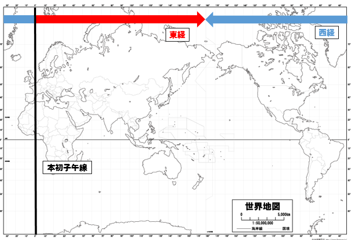
Cartographers have spent centuries imposing order on planetary physics, carving arbitrary lines across oceans and landmasses to make modern navigation possible. At the center of this artificial architecture sit two longitudinal anchors: the Prime Meridian and the International Date Line. While school textbooks often treat them as twin counterparts on opposite sides of the globe, their legal foundations, practical mechanics, and daily consequences operate under entirely different systems of human governance.
Understanding the operational differences between these meridians clarifies how humanity organizes geography and calendar time. One line serves as an immovable zero-point agreed upon by diplomatic consensus in the nineteenth century. The other remains a fluid, politically negotiated boundary that bends across thousands of nautical miles to accommodate island trade, election cycles, and local commerce.
📌 Key Takeaways:
- The Spatial Anchor: The Prime Meridian sits permanently at 0 degrees longitude, functioning as the origin point for worldwide geographic coordinates and Coordinated Universal Time (UTC).
- The Temporal Switch: The International Date Line roughly shadows the 180th meridian, but zigzags around national borders to trigger an immediate 24-hour calendar day change without splitting local jurisdictions.
- Sovereign Realignment: Unlike the internationally standardized Greenwich baseline, the Date Line has no single governing treaty; nations alter its path unilaterally to match their economic partners.
The 1884 Washington Conference and the Anchor at Greenwich
Every coordinate system requires a baseline. In October 1884, representatives from 25 nations gathered in Washington, D.C., for the International Meridian Conference to resolve an escalating maritime nightmare. Ships of different registries were navigating using disparate zero points, ranging from the Paris Meridian to Ferro in the Canary Islands. The conference selected the Greenwich Meridian, running directly through the transit instrument of the Royal Observatory Greenwich, as the initial meridian for longitude.
The decision established 0 degrees longitude as the permanent reference line dividing the Eastern and Western Hemispheres. It provided the world with an unambiguous geographical starting point. When an aircraft leaves Heathrow or an ocean carrier departs Rotterdam, its position relative to the equator and this specific longitudinal slice governs global navigation data.
The Prime Meridian also established the baseline for international time measurement. Originally known as Greenwich Mean Time (GMT) and later standardized into Coordinated Universal Time (UTC), UTC±0 remains tied to this exact longitudinal cut. The line itself traverses eight nations across Europe and Africa, including the United Kingdom, France, Spain, Algeria, Mali, Burkina Faso, Togo, and Ghana, before disappearing into Queen Maud Land in Antarctica. Its geographic coordinates never bend. If a house sits on the line in suburban London or the plains of West Africa, half the structure rests in the Eastern Hemisphere and half in the Western Hemisphere.
The 180th Meridian and the Mechanics of the Calendar Switch
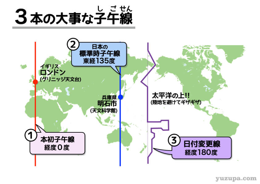
Directly opposite Greenwich across the planet sits the antimeridian at 180 degrees longitude. While pure geometry dictates that this meridian mirrors the zero line, human logistics quickly complicated that simplicity. The 180th meridian bisects open waters across the Pacific Ocean, but it also slices through sovereign archipelagoes, islands, and coastlines. Leaving the boundary as a straight, rigid line would have forced single administrative territories to experience two different days simultaneously.
The International Date Line developed as an adaptive, pragmatic response. It marks the spot where every calendar day officially begins and ends. Crossing the line westward means advancing a full day into tomorrow. Crossing eastward means stepping back 24 hours into yesterday.
Crucially, no international treaty officially mandates the path of the International Date Line. While the 1884 conference established the 180th meridian as an astronomical and cartographic reference, the actual Date Line is an informal convention. International maritime organizations, cartographers, and commercial airlines respect local laws regarding which side of the boundary an island group occupies. National sovereignty determines local calendar time, which explains why the line swerves dramatically across oceanic space while the Prime Meridian remains laser-straight.
Side-by-Side Cartographic and Temporal Breakdown
To clarify the structural contrasts between these two planetary boundaries, the following comparison highlights their legal mandates, physical alignments, and temporal functions across the globe.
| Core Feature | Prime Meridian | International Date Line |
|---|---|---|
| Longitudinal Position | Exactly 0° longitude | Roughly 180° longitude (antimeridian), with dynamic jogs |
| Geometric Path | Completely straight; runs pole to pole through 8 countries | Zigzags through the Pacific Ocean; avoids landmass divisions |
| Governing Authority | 1884 International Meridian Conference treaty consensus | Customary international practice governed by sovereign nations |
| Primary Function | Anchors geographic coordinates and UTC±0 baseline | Executes the 24-hour calendar day change |
| Impact on Clock Time | Calculates hourly time zones (+1 hour per 15° east) | Shifts the calendar date by exactly 24 hours |
| Hemispheric Division | Defines the boundary between Eastern and Western Hemispheres | Marks the westernmost and easternmost limits of local time |
Why the Date Line Zigzags: The Kiribati and Samoan Precedents
Because the International Date Line is governed by national decree rather than maritime treaty, economic necessity routinely reshapes Pacific cartography. The most dramatic adjustment occurred in late 1994, spearheaded by the Republic of Kiribati.
Kiribati spans an ocean area roughly the size of the continental United States. Before 1995, the 180th meridian cut directly through the middle of the island nation. The Gilbert Islands sat on the western side of the line, while the Phoenix and Line Islands sat on the eastern side. As a result, government offices in Tarawa could only conduct official radio and commercial business with their eastern territories on the four overlapping weekdays when both sides shared a workweek.
President Teburoro Tito enacted the historic Kiribati time shift, effective January 1, 1995. The country simply drew a massive 1,000-mile eastward loop around the Line Islands, pulling its entire national territory into the Asian-Pacific side of the calendar. To do this without throwing global time standards into chaos, Kiribati invented the world's first UTC+13 and UTC+14 time zones. The practical result was that Caroline Island, quickly rebranded as Millennium Island, became the first piece of land on Earth to see the sunrise of the year 2000.
Samoa executed a similar shift in December 2011. For over a century, Samoa had remained on the American side of the Date Line (UTC-11) to facilitate trade with California and Hawaii. By the early 2000s, however, Samoa's economic reliance had shifted toward Australia and New Zealand. Operating on the opposite side of the Date Line meant losing two full working days each week. While Apia was working on Friday, Sydney was already on Saturday; while Sydney was working on Monday, Apia was observing Sunday.
Prime Minister Tuilaepa Sailele Malielegaoi solved the problem decisively. Samoa erased Friday, December 30, 2011, jumping straight from 11:59 p.m. on December 29 to the morning of December 31. Tokelau followed simultaneously. With that single legislative maneuver, Samoa moved across the line to UTC+13, aligning its standard business operations with Auckland and Sydney.
Modern Geodesy, Satellites, and the 102-Meter Offset
Modern satellite navigation has introduced a fascinating technical nuance to the concept of the Prime Meridian itself. Visitors standing at the Royal Observatory Greenwich often place one foot on either side of the brass strip embedded in the courtyard cobblestones, assuming they are straddling 0°0'0" longitude.
Modern GPS devices disagree. Pull up a smartphone mapping app at the historic brass marker, and the readout indicates approximately 0°0'5.3" West. The modern reference meridian sits roughly 102.5 meters (336 feet) east of the historic Airy Transit Circle telescope.
This gap exists because nineteenth-century astronomers relied on plumb bobs and mercury pools aligned with local gravity to calibrate their meridian measurements. Modern satellite networks operate on the World Geodetic System 1984 (WGS84) reference frame, maintained by the International Earth Rotation and Reference Systems Service (IERS). WGS84 measures coordinates relative to the Earth's center of mass rather than surface gravitational deflections. This shift moved the true zero meridian eastward through Greenwich Park, though the conceptual authority of Greenwich as the planetary anchor remains intact.
Meanwhile, the International Date Line has adapted seamlessly to computer networks. Global flight dispatch systems, financial trading engines, and telecommunications protocols rely on Coordinated Universal Time running along microsecond-precise atomic clocks. When an Airbus A350 crosses the Pacific from Tokyo to San Francisco, flight management systems do not stop running internal clocks. Instead, they track UTC continuously, recalculating local arrival stamps only to match ground-level civil time zone boundaries on the receiving end.
Frequently Asked Questions (FAQ)
What happens to your calendar date if you cross the International Date Line by plane?
When flying westward from North America to Asia, you skip forward 24 hours, effectively losing a full day on the calendar. Conversely, flying eastward from Asia to North America means you repeat the same calendar date, arriving at your destination at roughly the same hour, or earlier, than when your flight originally departed.
Does the Prime Meridian ever change its geographic coordinates?
No. The geographic location of the Prime Meridian at 0 degrees longitude is an immovable coordinate baseline. While modern satellite geodesy (WGS84) adjusted the reference line 102.5 meters east of the historic 1884 Greenwich brass rail to align with Earth's center of mass, its baseline position as the worldwide spatial coordinate origin remains fixed.
Can a country move itself across the International Date Line at will?
Yes. Because the Date Line is an informal convention rather than a rigid treaty border, sovereign governments retain full legal authority to adjust their local time zones. Kiribati did this in 1995 and Samoa followed in 2011. Both shifted their entire commercial workweek across the line without requiring approval from any international body.
Navigating the Global Grid in 2026 and Beyond
Human beings live inside an artificial temporal construct designed to balance the physical rotation of the Earth with the practical realities of industrial civilization. The Prime Meridian provides the rigid mathematical backbone: an immovable, internationally standardized origin point that guarantees accurate flight corridors, satellite tracking, and global mapping grids.
The International Date Line provides the necessary flexibility. By bending around sovereign territory and adapting to the trade realities of Pacific nations, the Date Line proves that time management on Earth is an instrument of human commerce rather than pure geometry. Knowing the difference between these two meridians is not just a matter of mastering cartographic terminology, it explains how modern networks keep billions of travelers, financial markets, and logistics hubs moving in unison across an endlessly turning globe.
